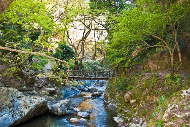
Mili Gorge
Mili Gorge is a stunning green oasis near the town of Rethymno. It is actuallya ravine inside which hosts a huge number of plants and trees, a real botanic garden. It is located north of the village Chromonastiri and south of Xero Chorio.
In recent years it attracts many walkers who trek along a nice trail. At the middle of the canyon we meet the deserted village of Mili (i.e. Mills) which is divided into two neighborhoods, Ano (Upper) and Kato (Lower) Mili. Its name is taken after the water mills that were housed in the gorge, about 30. The villagers were mostly millers and almost all cereals in the region and the surrounding villages were milled at Mili.
Today we can see in good condition only one watermill that has been renovated so the visitors can get an idea of how they worked. Apart from the many mills, there are many gardens with fruit trees and vegetables. The water never stops running from the springs located in the canyon at various points, with the larger springs being that of Saint Anthony and Five Virgins. Along its route, the water creates small waterfalls and lakes where you take a refreshing bath under the shade of huge planes.
The last residents left Mili in 1972 and since then it is deserted, but now a house has become a cafe-restaurant for guests. The fear for landslides was the reason that led the villagers to leave and build high above the gorge, on the west, the village New Mili.
Apart from the mills and old houses, there is a plethora of impressive churches. The first is the cavernous church of St. Anthony in a stunning landscape. There is also the cavernous church of St. John. Shortly after the village there is the cemetery church of the Holy Five Virgins. Shortly after Kato Mili we meet the cavernous chapels of Agia Paraskevi and Agios Nikolaos.
• Prefecture: Rethymnon
• Type: Hiking gorge, Signed trail
• Water: Water all year round
• Length (km): 2.5
• Altitude difference (m): 190
• Difficulty (0-10): 1
• Hiking Hours: 2.5
• Accessibility: Paved road
Patsos Gorge
The gorge of Patsos or Agios Antonios is located 8 km southwest of the Monastery of Arkadi, in the heart of the lush province of Amari. The water of the gorge is poured in the the dam of Potamoi. Trekking in the gorge is very easy, since it is managed by the Forest Service.
The gorge offers facilities for picnic, with a spring of running water near the river. A beautiful attraction of the gorge is the cavernous church of St. Anthony in the rocky walls, a former temple of Hermes. From there you can follow the trail towards Potami dam till a dead end with a beautiful cavernous waterfall and then return back. On the sides of the gorge there is an observation deck for birds in the area.
The name of the gorge comes from the homonym village. Patsos village is located near the foot of the hill of Soros at an altitude of 490 meters, and is 30 km south of Rethymno. Nearby villages are Karines, Spilia and Gerakari. The area has rich vegetation. Vegetation and crops are lush due to the numerous springs of water available in the wider area. The water is of very good quality and runs all over the year.
• Prefecture: Rethymnon
• Type: Hiking gorge
• Water: Water till spring
• Altitude difference (m): 100
• Difficulty (0-10): 1
• Hiking Hours: 2
• Accessibility: Paved road
kourtaliotis gorge
The Gorge of Kourtaliotis is located 22km south of Rethymno and has a length of 3km. It is one of the most spectacular natural attractions of Rethymnon. It starts from the village Koxare and flows between the mountains Kouroupis (984 m) and Xiro Oros (Dry Mountain – 904m). The huge cliffs of the canyon reach a height of 600 meters and are full of openings and caves, where significant fauna species live. The canyon is crossed by the Kourtaliotis River which flows up to Lake Preveli, after merging with Frati Gorge. In its latest part it is called Big River.
It is a wonderful gorge worth visiting and trekking along its riverbed, while playing with water. The canyon is crossed by a road, but walking in it is really nice. By following the steps at the side of street Koxare – Asomatos, you reach the bottom of the gorge, where the church of St. Nicholas is located. The springs of Kourtaliotis, near the chapel, are one of the nicest attractions of the gorge.
This area in south central coast of Crete is very important for the conservation of endangered birds of prey like vulture, since it hosts one of the last breeding pairs in the Balkans. Here others species find shelter such as buzzards, the Golden Eagle and Bonelli’s Eagle. The importance of the area for birds of prey can be explained by its location, that serves as a link between the White Mountains and the mountains of central Crete (Psiloritis and Asterousia).
Kourtaliotiko has excellent aesthetic, biological and ecological value. In addition to the clusters of Theophrastus Palm trees (Phoenix theophrastii) which is the second largest palm forest of Crete, on the slopes of the gorge someone can find rich vegetation, while in the estuary of the river there are sand dunes and formations of posidonia (Posidonia oceanica), which are among the most protected marine plants. Important animals of the region of Kourtaliotiko gorge is the waterturtle (Mauremys caspica) and the local fresh-water snake (Elaphe situla). They are protected by the EU Directive on the Conservation of Natural Habitats (92/43/EEC).
• Prefecture: Rethymnon
• Type: Hiking gorge
• Water: Water all year round, Springs
• Length (km): 7
• Altitude difference (m): 210
• Difficulty (0-10): 3
• Hiking Hours: 4
• Accessibility: Paved road